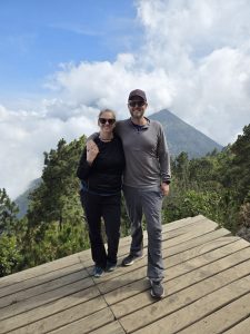
Andrew and I hiked Acatenango Volcano near Antigua, Guatemala, this weekend. We signed up for a guided group hike with Ox Expeditions (US$99 per person) without really knowing what we were getting into, incorrectly assuming we’d be fine with no training or preparation because it is an overnight hike and one of Guatemala’s most popular tourist activities. How difficult could one day up and one day down be if all the gringos who visit Antigua do it? My flippant arrogance is never-ending.
The hike is up a dormant volcano called Acatenango, with the main purpose of viewing an active neighboring volcano called Fuego (fire in Spanish). Fuego is known for its frequent eruptions, and we were excited for a night of stargazing and eruption watching. The hike starts at 7,900 feet (2,400 meters), climbs up Acatenango to the campsite at 11,600 feet (3,500 meters), and is about 4.2 miles one way. I’m not a numbers lady and I didn’t pay any attention to these details. I just knew we started at about 9 am and would reach camp around 2:30 pm. That sounded nice to me.

Once at camp, hikers have the option to do an evening hike to a ridge to get a better view of Fuego (there isn’t much elevation gain but the trail goes down and back up steeply and is a little under 3 miles roundtrip). We had a great view of Fuego from camp, so Andrew and I weren’t doing that one. It also costs an extra US$40/person. There is another optional hike at 4 am the next morning to the summit of Acatenango for sunrise. It’s about 1.5 miles roundtrip from camp with an elevation gain of 1,500 feet, and is included in the cost of the hike. Andrew and I were planning on doing that one.
Hike Prep

We met at the Ox office in Antigua at 6:30 on Saturday morning. There were 22 hikers and our guide Alonzo. We would pick up a crew of cooks and porters on the way. Ox lets people borrow most gear for free (well, included in the price of the tour), so we were all lining up for rain ponchos, beanies, jackets, fleeces, headlamps, gloves, and even backpacks, in exchange for an ID. We were there on May 10, in the beginning of Guatemala’s rainy season, and ponchos were mandatory. I borrowed a big backpack, poncho, jacket, and beanie. Andrew borrowed a poncho and a jacket. I brought my hiking poles from home and Andrew rented a pair from the starting point of our hike for Q20 (about US$2.60).
Each hiker was to carry their own pack with 4.5 liters of water, snacks, one shared item (pasta for dinner, a loaf of bread for breakfast, jam, nutella, wine, etc.), a poncho, jacket, fleece, gloves, hat, headlamp, toilet paper, sunscreen, toiletries, and any other personal items. During our pre-hike meeting the evening before, our guide said we could hire a porter to carry our pack for Q200 (about US$26) per way. I had a momentary flare up of pride and told Andrew I didn’t want to hire a porter, but when the guide said the water alone weighs 10 pounds, I told my ego to shut up and raised my hand for a porter. So all I would be carrying on my back was my daypack with a small bottle of water, gatorade, snacks, and a few odds and ends. Andrew was going to carry his own pack.
After getting our gear together at the office, we piled into 2 buses and were driven a few blocks away to a cute restaurant (Rainbow Cafe) for coffee, tea, and breakfast burritos. Everyone lined up to use the last toilets and sink with running water and soap we’d have access to for the next 28 hours. We loaded back into the buses and drove a little over an hour to La Soledad, the hike’s starting point, where porters took bags for anyone who hired them (there were a handful of people in our group using porters) and hikers could rent poles or buy last-minute snacks and drinks.
Hiking Up (7,952–11,646 feet)
The start of the hike is steep and it doesn’t relent for almost 2.5 miles. I quickly realized I should have paid more attention to the elevation stats, and I was grateful to my porter. The first section is through farmland and climbs to 9,000 feet in less than 1 mile. It took about 1.5 hours for this section, but we stopped every 30 minutes for a much-needed water and snack break. Our group naturally divided into 2 subgroups during this part: the younger and/or fitter group who arrived at the break points first, and the older and/or less experienced hikers who stumbled into the breaks more gassed than the first crew. I belonged to the second group, and Andrew kept me company.
After the farmland, we traversed a cloud forest via steep switchbacks for maybe .75 miles. I was looking forward to the switchbacks because I thought they would offer a slight reprieve from the nearly vertical path through the farmland, but my body didn’t register much improvement. After the cloud forest, we entered the alpine forest (the BEST part). The switchbacks continued for a while longer and then we stretched out to another long, steep straightaway leading to our lunch break. At lunch, we were 2.25 miles in, almost 11,000 feet high, and had been hiking for about 3 hours.
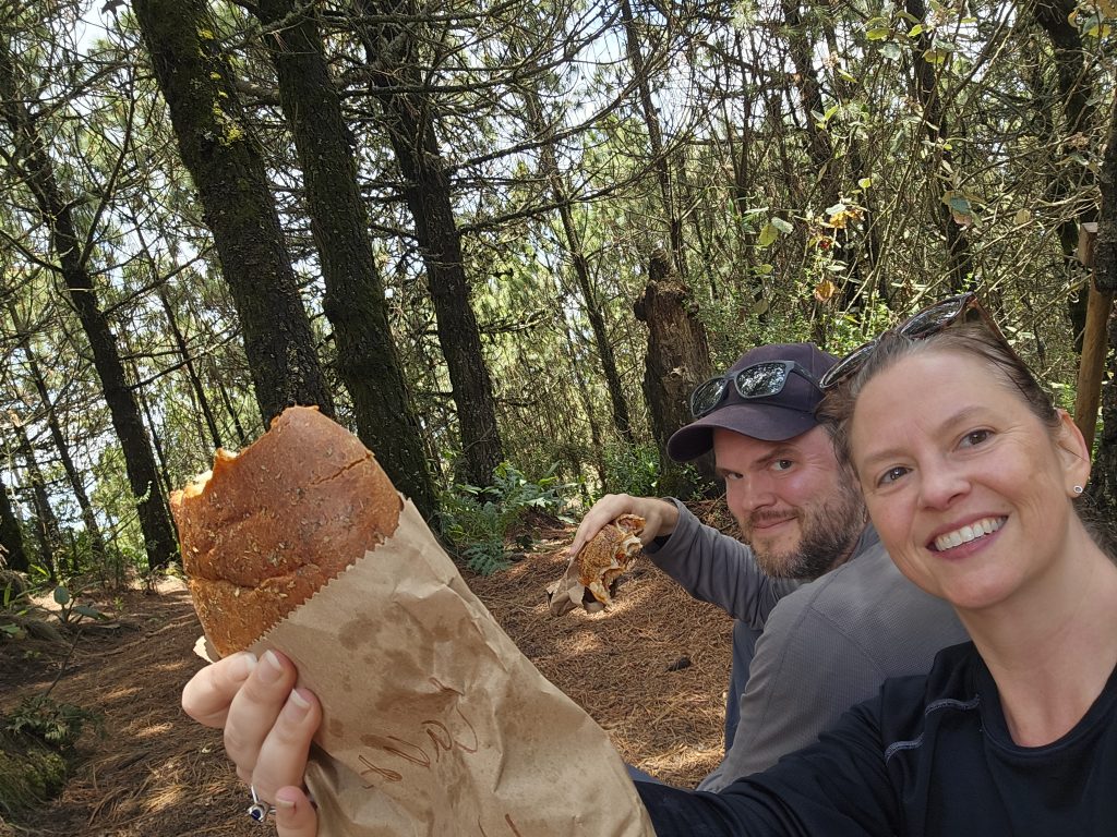
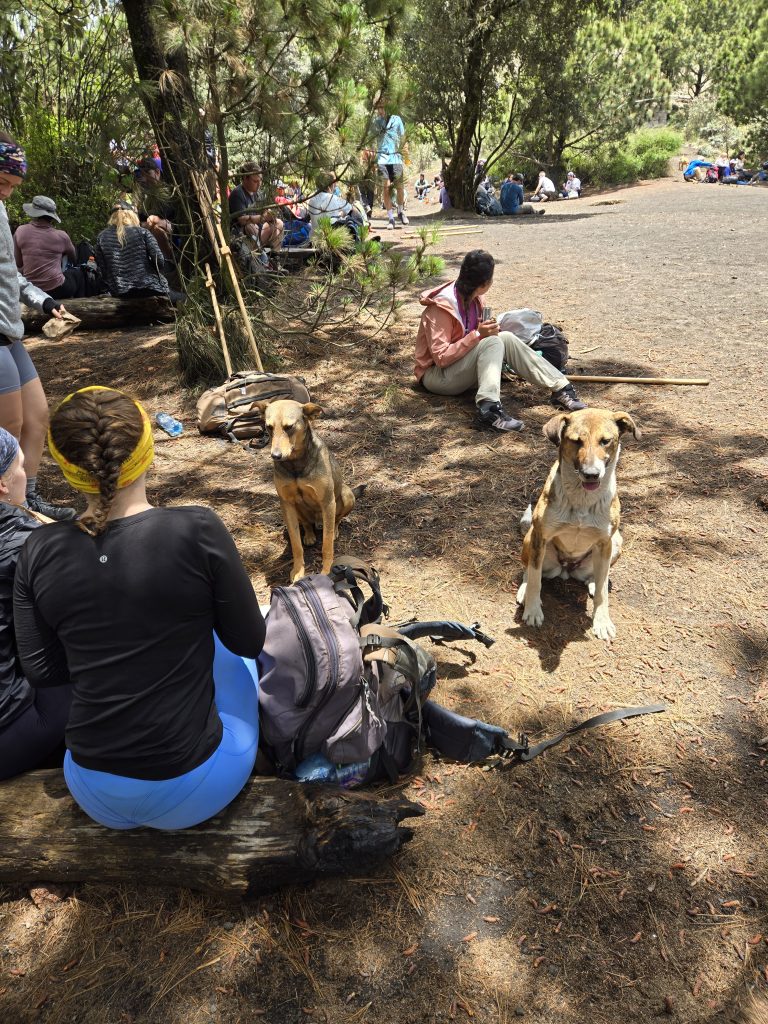
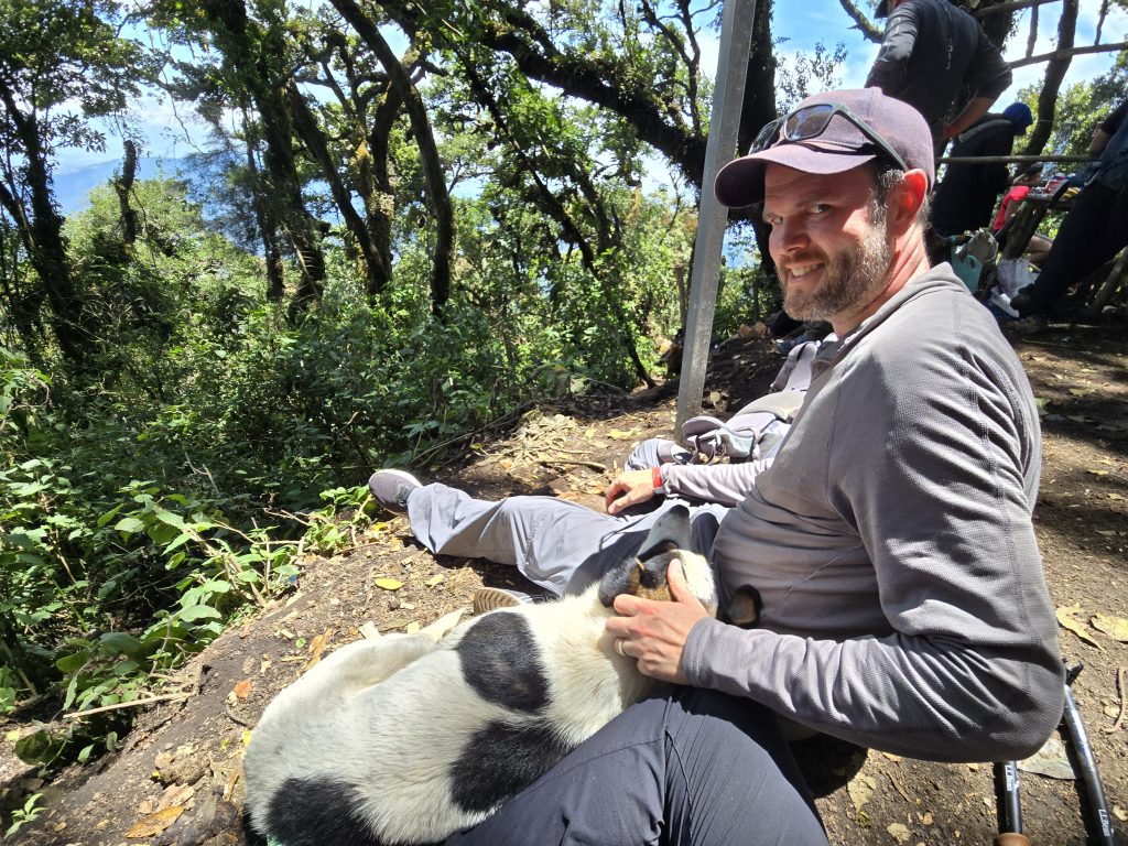
I sat down under the trees and pulled out the giant veggie empanada that Ox gave me that morning in the office (meat eaters had ham in theirs). We all ate and rested for about 45 minutes with the trail dogs who accompanied us the whole weekend, and then it was time for the last 2 miles of trail. We stayed in the alpine forest and aside from one or two steep sections, the trail was blissfully, relatively flat until we arrived at camp. During the hike, we passed 1 park checkpoint where each hiker paid Q50 for the entrance fee and another where each paid Q50 for the camping fee (for a total of Q100/person, which is about US$13).
At Camp
We reached camp a little after 2 pm and everyone dropped their bags and took in the views of Fuego. It was cloudy but the wind blew the clouds away frequently, so we were treated to clear but sporadic views of the volcano. We heard a few booms as it erupted, but Alonzo said we wouldn’t see the eruptions until it was dark.
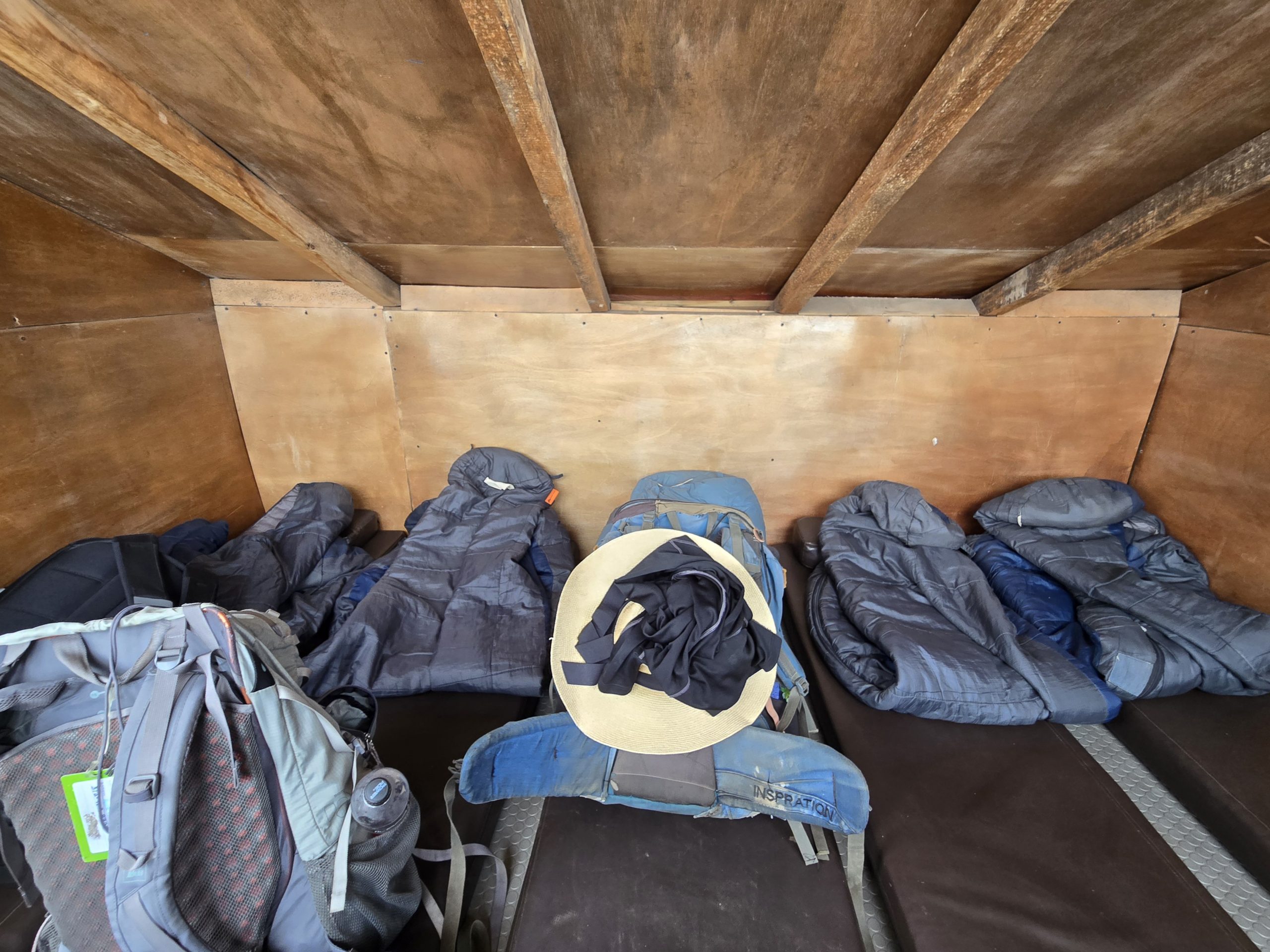
After we all had a chance to take photos, our guide told us to split into groups of 4 or 5 to share a cabin. Andrew and I grabbed our bags and let the guide sort us with another nomadic couple (Mariel and Connor) and Victor from Florida, and I got my first glimpse of the cabin. I should have looked into the sleeping arrangements ahead of time but, again, I didn’t really put any thought or planning into this experience. Each cabin fit 5 sleeping pads with a couple of inches of space between them. On top of each pad was a sleeping bag. There was a walkway of about 2 feet between the end of the sleeping mats and the wall, and a few hooks for our bags. The roof sloped down from the front to the back of the cabin, and I still had to hunch over when standing at the tallest point. The front wall redeemed the situation: it was all windows starting about halfway up, and we were directly facing Fuego. But that didn’t mean I was happy to share such tight quarters with 3 strangers, 1 of whom turned out to be quite the snorer. (I was even less happy the next day when another camper told me she shared a cabin with only one other woman. Oh, well, what can you do?)
Evening Activities
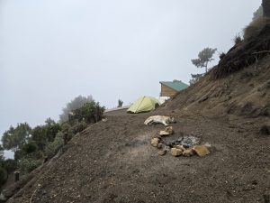
In addition to the cabins, camp had two stinky, sludgy outhouses with a drop toilet each; an open-air, covered kitchen and dining area; a firepit; and a wooden platform extending over a cliff with the best view of Fuego.
Only 6 of our group decided to stay at camp rather than hike the ridge to get a closer view of Fuego, including me and Andrew. I was exhausted, my right knee was hobbled (as expected), and I wanted to rebuild some strength for our 4 am hike to the summit. Also, one of the two outhouses was down a steep, slippery incline, and Alonzo was making everyone climb down and up it to demonstrate that they had enough dexterity for the ridge hike. I didn’t even have the energy to attempt the demonstration, so I knew I made the right choice.
The crew made everyone hot chocolate and set out loaves of lemon bread before the ridge hikers left around 4:15. Before leaving, Alonzo told the rest of us that the crew staying behind would build a campfire for us at 5 and we would get dinner at 6:30. The group going on the hike wouldn’t be back until about 8, and they would eat dinner then. I was hoping to be asleep before they even returned. Our cabin-mate Connor also decided to skip the ridge hike, but Victor and Mariel were going and I figured my chances of falling asleep were significantly higher in a cabin of 3 rather than 5.
Thick clouds rolled in around the time the ridge hikers left. Some of the remaining folks went to take naps, and Andrew and I hung out with Connor, chatting and reading in the dining area and on the platform.
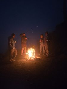

Soon we had a fire and then our dinner of veggie pasta was ready. Everyone else emerged from their cabins. The crew opened up bottles of wine and I was the only person who stuck with water. The altitude was getting to me and I couldn’t imagine adding alcohol to the mix. The cloud cover was still obscuring all the views, and when it started raining around 7 we were all happy with the decision to stay at camp. After dinner, I went to bed at about 7:30. Unfortunately I couldn’t get comfortable, and I was tossing and turning when everyone else returned from the hike, while they ate dinner, as they came to bed, and even as they fell asleep and started snoring. I used to be able to fall asleep anywhere at any time, and I really miss those days.
The rain got heavier throughout the evening and we heard from the returning hikers that, on the way back, it was so foggy and dark they couldn’t see beyond each single step they took, they were rained on, they didn’t reach the top of the ridge because Alonzo said the lightning was too dangerous, and one hiker sacrificed his drone to the volcano in an attempt to see it. In their photos, they looked like aliens wandering lost in an ominous, mist-shrouded landscape, each poncho-draped silhouette shooting a beam of light into the darkness from their headlamps, illuminating nothing but a short tunnel directly in front of themselves, disconnected and cold. In short, Andrew and I were happy we didn’t go. But the photos were really cool.
Volcanic Activity
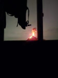
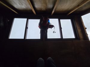
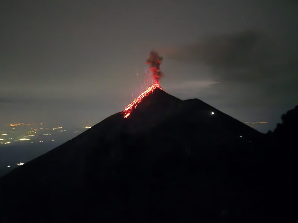
The rain stopped a few hours after the ridge crew returned and around 2 am Fuego started a show for us. I don’t think anyone was really sleeping well in the cabins, most people not at all, so when someone let out the call to look outside, we all heard it. We popped up from our sleeping bags and lined up in the cabin window for a stunning display. This photo is blurry and terrible, but it shows how good those cabin windows are. We were that close to an erupting volcano!
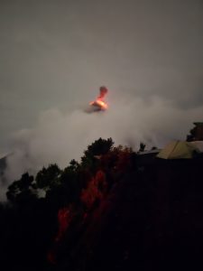
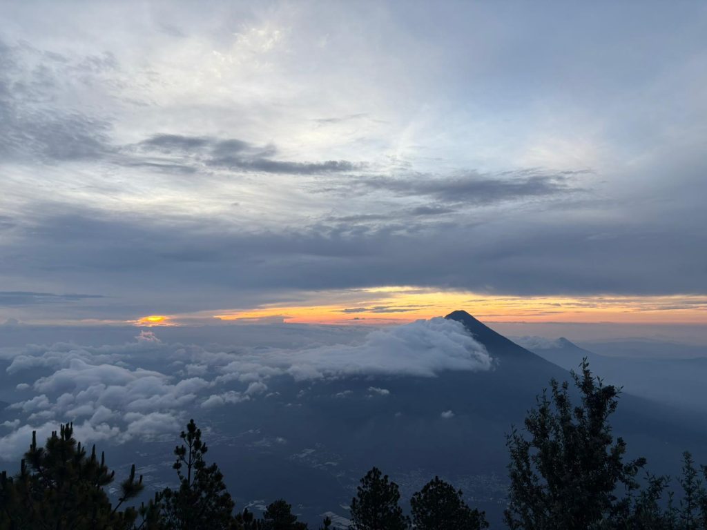
Fuego continued to erupt dramatically for the next 2 hours, in 10–20 minute intervals. Almost everyone went outside at one point to watch, and it was a surreal bonding experience in the middle of the night, all of us in a sleep-deprived daze. At around 3:15, Alonzo went to all the cabins to let people know if they wanted to do the summit hike, they needed to be ready to go by 3:30. Andrew and I had both gotten almost no sleep and we couldn’t muster the energy. Ten years ago, I would have forced myself to do it, but now that I’m in my 40s I’m being easier on myself. I saw Fuego erupt many amazing times, and we had an arduous trek down Acatenango in just a few hours, so I stayed at camp. I heard people excitedly getting up and rallying for the sunrise hike; I was sad to be missing it but not sad enough to push myself into something I knew I would be miserable doing. Aging is interesting.
About 45 minutes after the sunrise hikers left, I went back outside to watch Fuego erupt a few more times and chatted with the people outside. Three of them had attempted the sunrise hike and turned back. It turns out Alonzo told everyone they would stop after 15 minutes of hiking and have the option to return to camp. He might even tell people they had to return, against their wishes, if he didn’t think they would make the summit in time. After that, hikers had to complete the summit, no matter how difficult it was, because there wouldn’t be a guide or crew member to walk them back to camp. One of the women said she didn’t even make it to the 15-minute checkpoint; she turned around after 5 minutes. Two other hikers said they turned around at the checkpoint because the terrain was like quicksand. They were barely moving despite their skyrocketing heart rates. Within another 15 minutes, Fuego stopped erupting and I finally fell asleep for a couple of hours.
Downhill
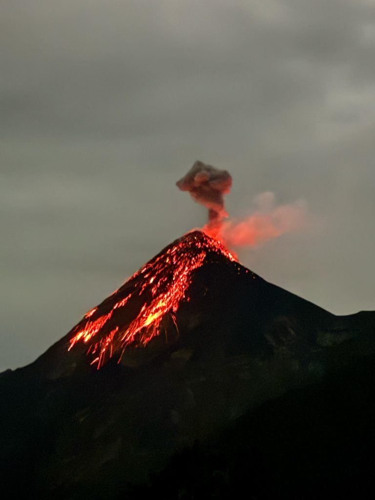
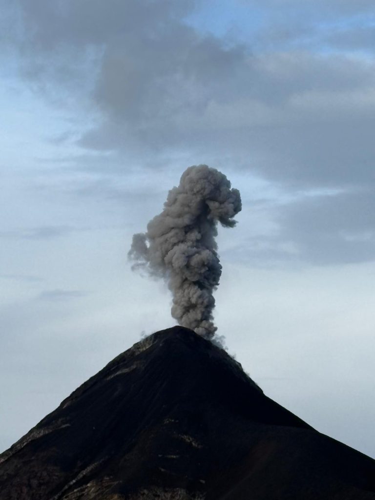
I hate hiking down mountains (and volcanos). In every hike I’ve ever done, the descent is the worst. I’ll spare you the boring details. We made it down Acatenango in about 1.5 hours, I fell once but was in good company with at least 4 other people falling. I didn’t cry, which is also something I track during descents, so overall it’s a win. And look at the photos below. What an amazing force of nature we had the privilege of experiencing.
Pingback:A Month in Antigua, Guatemala – Slowly As We Go